Leave Oakland 10:30.
Lunch in Oakdale at Sno White's Drive-in. "Under new management"; the wicked witch must have sold it.
Pass Hershey's chocolate factory; tempted, though.
Heavy westbound traffic on Yosemite Highway 120 (last day of July 4th weekend), but not bad eastbound.
Enter the park; ranger warns us of heavy congestion in Yosemite Valley. We laugh and tell her we are going to Tioga Pass; she laughs too and says she prefers it as well.
Stop at Tuolumne Meadow, a favorite place for us; buy souvenir hat to add to collection.
Many signs on road say "Watch for rocks"; they must be extremely rare and worth looking for.
Reach Lee Vining at 5 PM; stat at Lake View Lodge. Is not a lodge, not all rooms have a view, but not bad. We have a nice cabin/cottage.
Dinner at Bodie Mike's BBQ; also not bad. Young woman at next table covered with tattoos, including her shaved head, appears to be sitting with her parents. Serious cognitive dissonance.
Afterwards, visit historic park and Upside-Down House, then return and try to figure out where we packed things, a first-day-out ritual.
Monday, July 7
Up early, go over to Nicely's Restaurant for breakfast. Wait till it opens at 7.
Good standard American fare; eggs, coffee, etc.
Study the map: today we visit Hawthorne (old courthouse, vast ammo dump), Goldfield (old courthouse built like medieval castle), and stay in Tonopah.
Pick up brochure on ghost town of Bodie. Descried in its heyday as "a sea of sin, lashed by the tempests of lust and passion." Sounds like my kind of place.
Stop at Mono Lake visitor center. Surprised to notice that on this trip so far (Yosemite and Mono), the predominant foreign language I hear is not German, but French, with Russian second.
Walk some trails above
the lake
, gray in the overcast today.
Return to car and drive north 7 miles, then turn east towards Hawthorne NV.
Road is straight as a string up to the Nevada border. And deserted; we see 14 other vehicles in the 55 miles to Hawthorne.
Photograph 1880 courthouse, now boarded up and fenced off.
Ordnance is very popular here; with the mines depleted, Hawthorne owes its life to the immense Army ammunition factory and storage depot nearby. People use shell casings as lawn ornaments, and the McDonald's parking lot is surrounded with dummy bombs and torpedoes. There is a local "ordnance museum".
Down the road in neighboring towns, big signs say "No explosives-laden vehicles allowed to park in this city". Though some towns are so flimsy, one big firecracker might flatten them.
The "Wild Cat Ranch" south of Mina is closed; sex must have lost its appeal. The trailers and the faux Roman decor look run down.
Reach Tonopah (whose high-school team is the Muckers); check into Mizpah Hotel, a nice place.
Take naps, then drive to Goldfield to see courthouse. Thunder and lightning and rain beside the road, but none on it.
Goldfield is basically a ghost town (though still the county seat), but a marvelous bunch of relics.
Dinner at Mizpah Hotel; service a little uneven, but in Tonopah you don't look for five-star elegance.
Tuesday, July 8
Get up and pack for day's trip; eat in room to save time before midday desert heat.
Drive through vast sagebrush desert and Joshua-tree woodlands.
Stop at town of Rachel, center of "Area 51" fandom, at the Little Alee-Inn (get it?).
Buy an alien-head soap bar as a gift, and a history of Area 51 for self.
Up US 93 to Pioche, and its two courthouses. The 1938 Moderne style building is attractive, but the famous 1872 "Million-dollar courthouse" has the most character.
It actually cost only about $16,000 but corrupt financing put the cost into seven figures. It was condemned and abandoned as unsafe before it was paid for.
It is now a museum of Lincoln County history, which we tour.
Pioche was a rough town in its day; 75 men died by violence before the first one of natural causes.
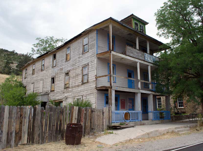
Also visit (without entering) Pioche's late, great
Mountain View Hotel. From 1895 when it was built until 1930 when the old courthouse was replaced, it was *the* place to stay in Pioche. Notable visitors included President Herbert Hoover.
Then back down the road and into Utah and Cedar City.
The Iron Gate B&B a very nice place; big guest rooms with lots of shelves etc. to put stuff out.
Everyone else here has come for the Utah Shakespeare Festival at the nearby Southern Utah University. After dinner we walk over to the campus.
Then to bed, to catch up on sleep.
Wednesday, July 9
Leave Cedar City; Iron Gate B&B and Winery a very nice place. Highly recommended, esp. if you can hold your own on Shakespeare knowledge with the other guests in the summer, who come for the nearby drama festival at Southern Utah U.
Ascend highway into mountains from plain. Change into warmer shirt.
Cedar City is in Iron County; reason for the name is apparent from the red iron-oxide rich cliffs on either side of the road.
Reach
Cedar Breaks Natl. Monument; it is as spectacular as we remembered.
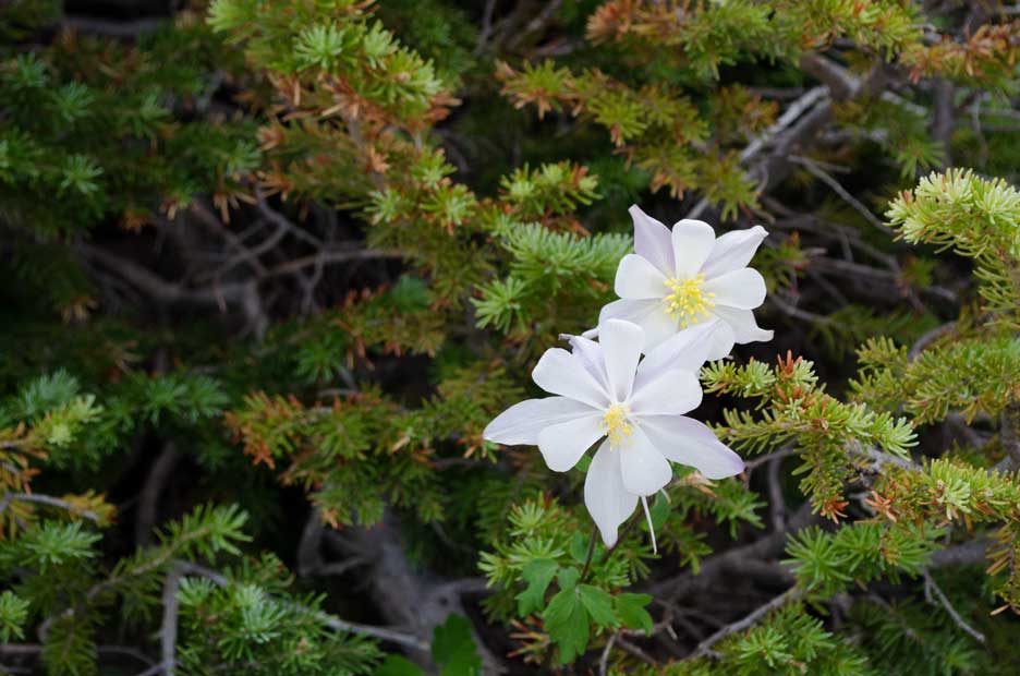
And, it appears to be the height of the
wildflower season; mountain bluebells, yarrow, columbine, Indian paintbrush are in profusion here at 10,500 feet elevation.
Hike around Point Supreme and Ramparts Trail.
Then drive to Chessmen Ridge Overlook and Sunset View turnouts, admire new vistas.
Back to visitor center and unpack lunch.
Hit the road to Zion. Pick up US 89 south.
Maynard Dixon Museum appears closed, must pass it by; console ourselves with ice cream at a rock shop & cafe.
Turn east on road into Zion. Pause at Canyon Overlook trail, climb it for about 100 yards, but it is steep and slippery with sand on the steps, and about 95 degrees temp; we bail.
Into the Long Tunnel to Canyon Junction, where it is "Death Proclaime'd" to drive a car without the Red Sticker for Zion Lodge guests. Reach lodge parking lot, check in to a quite attractive room whose A/C is off; turn both units on to the max.
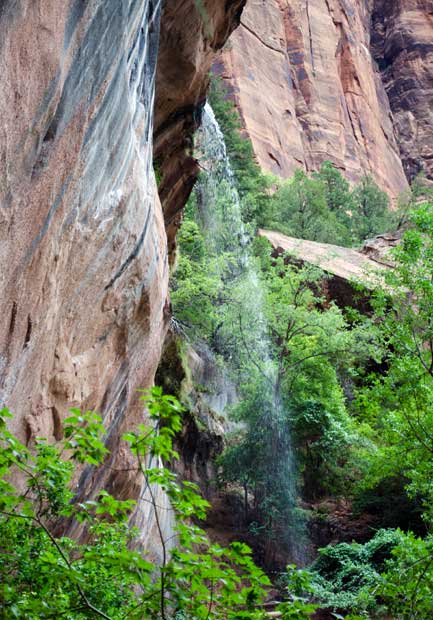
Joan takes a nap, while I reconnoitre the
Lower Emerald Pools
trail; a short way since I have to shower and get ready for dinner.
Afterwards, watch nearly-full moon rise above eastern ramparts; magical.
Transfer day's shooting to backups (about 300 photos, but really only 150 images; RAW + JPEG copy) and collapse into bed.
Thursday, July 10
Up early, with some more energy than last night; still, I'm glad to see it's overcast so I don't have to rush out to catch the dawn light on the hills.
Discover there are no laundry facilities in the valley, hmm. Well, we'll wait till we get to the North Rim and leave the windows open. I no longer need to use bug repellent; I put on my undershirt and they drop out of the sky.
Hike to Emerald Pools opposite the lodge, then up the Kayenta Trail and re-cross the river. Take shuttle bus to upstream end of road and follow the Riverside Walk. It begins to sprinkle, so we turn around and take the bus back to the lodge.
Bus driver points out hikers on trail to Angel's Landing, an extremely dangerous 3-foot wide knife-edge arete with a sheer thousand-foot dropoff. You do not make a second misstep on that trail.
Passengers crane their necks to see the daredevils. Cameras are pointed out the windows and up. It has been fun to watch tourists of all ages and nationalities agape and chattering in a dozen languages over the sights all up and down the valley.
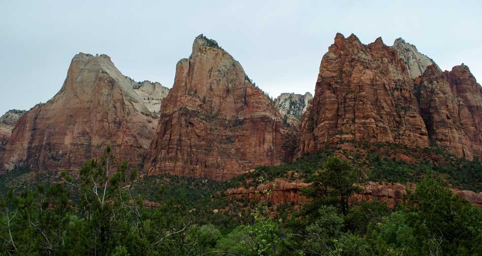
Back to lodge and well-earned naps. Then onto the down-canyon shuttle to the
Court of the Patriarchs
viewpoint, named for three dramatic peaks called Abraham, Isaac, and Jacob. (Prior to the arrival of Europeans, the Paiutes called them Curly, Moe and Larry.)
Pick up the next shuttle down to Canyon Junction for a view of the majestic Watchman mountain, then to the Zion Museum. Buy 2015 Zion calendar.
Up again to lodge, to shower and make selves presentable or at least bearable for dinner.
Friday, July 11
Up at 6; sky is clear. Take shuttle to Canyon Junction and photograph Watchman at dawn.
Then head up-canyon and do same for Patriarchs. Magnifique.
Go back to bed.
Get up again and go to breakfast, then take shuttle up to end of road and hike the
Riverside Walk
to its end. (You can go further, but there is no official trail; you have to walk in the river.)
Because of the extreme heat, abbreviated costumes are the norm. But one young lady of about 20, with what I believe to be her parents, took the cake and the rest of the bakery by wearing only her underwear, a bikini bra and panties. The three spoke French to each other; I suppose they see Utah as St. Tropez West. Sorry, no photos.
Fun fact: the Zion Canyon's Virgin River washes one million tons of rock and earth down the valley each year. Not only each year, but concentrated in the 15-20 days of heaviest flow.
Down-canyon to Big Bend for more shots, then to lodge and lunch.
Saturday, July 12
Check out of Zion Lodge just before 11 and hit the road to Grand Canyon, via Mt. Carmel Junction.
Speculate on possible new names for Zion features:
- Zoroaster's Mailbox
- The Outhouse of Abraham
- Shiva's Middle Finger
Pass through Kanab UT, stop for lunch; a prosperous little town with two Mormon churches. Popular site for filming Western movies, according to sidewalk monuments to actors and directors.
Cross the state line and enter the infamous "Arizona Strip": south of Utah's jurisdiction but hard to reach from AZ because of the Grand Canyon to the south, it was the home of many outlaws, and even today of some polygamous old-line (excommunicated) Mormons.
En route to park, pass through vast grassy meadows (former lakes, now filled in) flanked by low forests of pine and aspen; the Kaibab Plateau.
Enter Grand Canyon Park; 8800 feet altitude, 71 degrees Fahrenheit.
Our room is nowhere near ready; AZ is an hour earlier than UT because it doesn't go on Daylight Savings Time*, so we walk around the area until we can check in.
*Actually the Navajo Reservation which is encircled by the state _does_ go on DST.
Except that the Hopi Reservation, which is entirely encircled by the Navajo Reservation, does not; leaving AZ time zones looking like a set of concentric circles.
The log cabins at the North Rim are primitive, especially those artfully called Pioneer Style (which we're in). But it could be worse; our cabin was once a pair of separately rented rooms, since combined and with a new bathroom.
We find frequent employment for the flyswatter I brought, an item no traveler should leave home without IMHO.
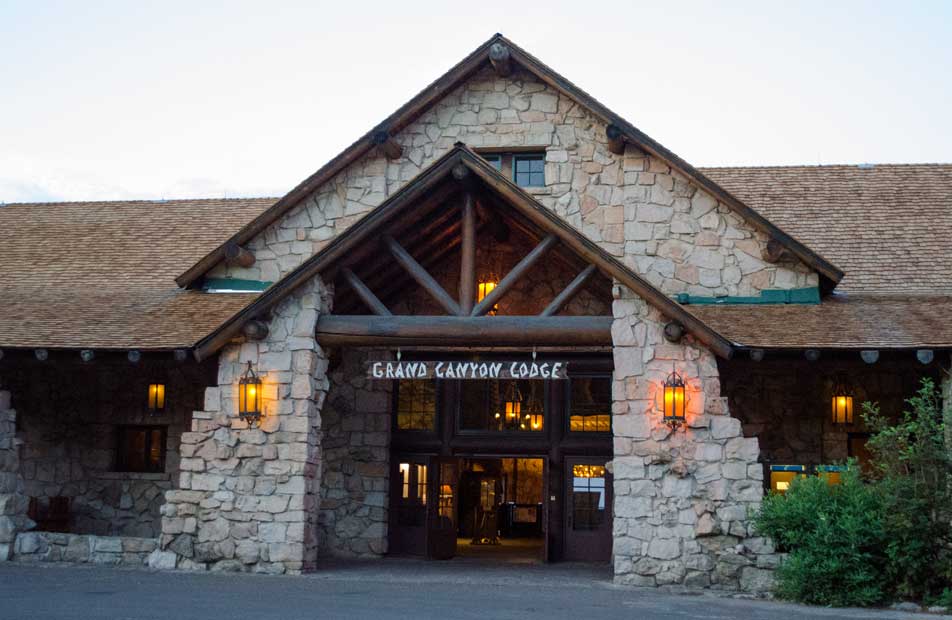
Later, we wander through the magnificent
Grand Canyon Lodge
and its spectacular overlook of the canyon.
Notice that the mule-ride concession into the canyon has added a 220-pound weight limit to prospective riders; 200 lbs. for the steeper route.
While waiting for dinner, we catch a performance by the Utah Old Time Fiddlers and Country Music Association (utaholdtimefiddlers.net) in the courtyard. They wind up with a rousing "Orange Blossom Special".
After dinner, we stand outside and watch distant lightning on the horizon to the southeast.
Sunday, July 13
Rise at 5 to catch sunrise on stone.
Lucky surprise:
nearly full moon
hangs low in west over cliffs.
Shoot photos for half an hour as sun rises, from different vantage points; Bright Angel Point, hotel veranda, points between.
Back to room, have spartan but quick breakfast and prepare for day's activity, namely trip to Point Imperial and Cape Royal along rim of canyon.
Travel to Point Imperial, highest spot reachable by road in park, 8800 feet; 68 degrees at 10:15, very mild.
After viewing, snapping sights there, travel to a variety of other spots on the way south to
Cape Royal
. We want to visit some today, check others out for more thorough view tomorrow.
Amble down and back, viewing wildflowers:
- wild cliff rose, scarlet penstemon, yarrow, lupine, "Skyrocket" (Ipomopsis), blue flax, blue and yellow daisies, sacred datura, prickly poppy (Argemone), evening primrose (Oenothera), salsify (Tragopogon).
Return to lodge, buy hat, take nap.
Go early to lodge before dinner to photograph late-afternoon light on cliffs. Rewarded with
rainbow
and lightning from South Rim thunderstorm.
After dinner, return to room and review photos, and GC generally.
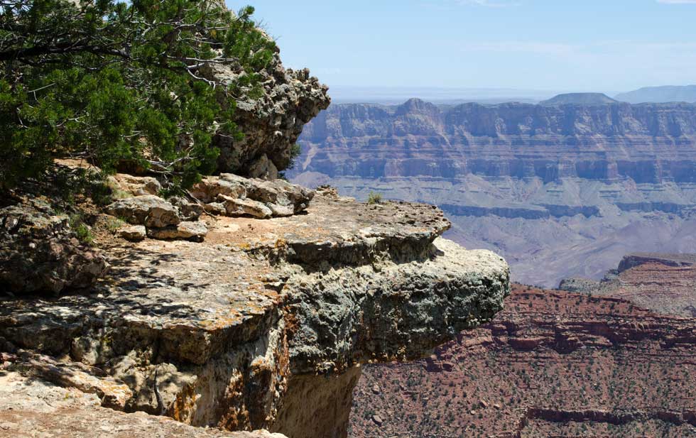
Have to admit, in some ways the Grand Canyon is a bit disappointing.
Partly because of its popularity; you would think it's all about ice cream and pony rides, with a bit of colored-rock scenery thrown in. The difficulty of finding a parking space in the very large lot further erodes the wilderness feeling.
But besides that, it's just of a scale beyond my comprehension. Zion was dramatic too, but in a narrow canyon the details of the rock walls, the pools, the river, were present to the eye. From here the South Rim is so far away it could be in another country; especially with the omnipresent canyon smog and haze, more like LA than the open spaces of the Old West. The fact that the Colorado River has cut through to rock laid down two billion years ago becomes just a number, obviously larger than a mere sixty million years ago when the dinosaurs vanished, but so?
What I relate to most here are individual features that stand out to the eye. Wotan's Throne, Angel's Window, Yoda's Nose (OK, I made that up). The totality is so immense that I simply tune out, especially with thirty other tourists at my elbow holding up their iPhones to capture the scene.
Monday, July 14
Wakened by loud thunder at 5 AM. Dress and go down to lodge to watch dawn arrive over the canyon.
Begin to see the appeal of the place outside of its Disneyland aspect. Still, the Drover's Inn at Frenchglen OR (pop. 12) and
Kiger Gorge
below Steen's Mountain are more my kind of place.
At breakfast in lodge dining room, watch storm of rain sweep across south rim, obscuring the horizon and mesas one by one.
Rain arrives, along with our pancakes. View it through window (heavy plate glass, with drop-down metal shutters just in case).
Then back to cabin. Is ADA-compliant but has no closets, drawers, shelves, or coat hooks; do they think disabled people go around naked? Or have no storage needs?
~10 AM; off to Cape Royal Road for day of hiking. Area is heavily forested, contrary to what one might expect; mostly ponderosa pine and aspen, except that in areas hit by Rim fire a few years ago young aspen have taken over.
Lots fewer people here today than on Sunday; nice.
Stop at Roosevelt Point for nature walk. Plaque includes this 1903 T.R. quote:
"Leave it as it is. You cannot improve on it. The ages have been at work, and man can only mar it. What you can do is to keep it for your children, your children's children, and for all who come after you."
Hike to
Cape Final
overlook, a spectacular scene of jutting rocks above empty space.
Eat, drink, photograph; retrace steps about 2.5 miles to car (easier said than done), drive back to lodge, rest.
GC fact: because the north side is higher, and therefore wetter, and both plateaus tilt down toward the south (toward the river in one case, away from it in the other), the tributary canyons on the north rim are much more deeply eroded. They extend roughly 4-6 times farther back from the Colorado River valley.
More dry lightning in west during dinner.
In bed by 9. Wakened at 11 by series of tremendous thunderbolts and lightning, very near, followed by torrential downpour.
Tuesday, July 15
Another thunderstorm rolls through about 3 AM, not quite as powerful but still strong: wind, rain, lightning, thunder.
I get up at 6 and go down to lodge. Canyon is spread out before dawn in misty pastels. Back to bed.
Up again at 8 for breakfast and rest of day.
Drive north through park and Kaibab Forest. Pass herd of couple dozen buffalo grazing in meadow.
Reach Fredonia AZ around noon. A tired dusty town with more places to buy ammo than food.
Dine on a Frappucino and an ice cream bar from Lynx Fueling, which has a convenience store.
First sighting of a Ron Paul sign on this trip, at Hurricane UT.
Reach St. George UT and check in to Best Western; enjoy civilized amenities after our GC Lodge cabin.
In fairness, the cabins despite their rustic - even primitive - character, are well maintained where it counts like the roof, plumbing, etc.
Dinner at the local Black Bear Diner; temp is 100 F at 7:15 PM.
Wednesday, July 16
Leave St. George ~9. Best Western Abbey Inn a good place: reasonably priced, conveniently located, high quality services. Good breakfast selection, too.
9 AM quickly becomes 8 AM as we leave Utah for AZ and NV.
Leave freeway for NV 169 through Moapa Valley, a well-watered green retirement community wannabe.
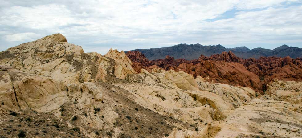
Reach
Valley of Fire
State Park. Very dramatic and colorful (mostly red) rock formations. Glad we came.
Getting hungry, though, have worked through our stash of food bars. It is a long though scenic drive around Lake Mead.
Former Lake Mead, maybe; it is down to a big puddle now, with all the boat launch ramps closed.
The "Lake Las Vegas" area is another world, almost impossible to imagine. You are driving on NV 167 through arid lifeless gray desert, come over a rise, and spang there you are, surrounded by fountains, palm trees, waterfalls, and emerald green lawns the size of Rhode Island. Except for the gaps where they haven't built yet, those are lifeless beige lots scraped into total barrenness.
There are plenty of those; apparently there was a huge building boom with LLV as The Next Big Thing and bank loans flowed in abundance. Then the real-estate crash came, and many projects were abandoned or changed hands for decreasing prices.
The LLV Hilton (formerly Aston) Spa & Resort seems to be an example; swank on the surface, but the restaurant is closed and the parking garage nearly empty.
As is the faux-Venetian shopping center with its campanile and shop-filled "Ponte Vecchio" bridge over the lake, I mean the lago. We wandered down the cobblestoned alleys looking for a place to have lunch; only one out of maybe 15 storefronts is occupied, and they are bars, gift shops, and a "business center" offering mailboxes and fax service.
We find a coffee shop (it shares a space with the business center) and get a pre-made sandwich and iced coffee.
At least it's air-conditioned; the thermometer reads 108.
Dinner at Bernard's Bistro, a survivor at LLV and a surprisingly good one. The decor features mementos from the Titanic, which may be a metaphor for the LLV business community.
Thursday, July 17
Breakfast in cafe on Via Bel Canto alley, where we are only customers. Return through hotel dining room, a couple acres in size, where two tables are occupied. Check out with great relief.
Pass The Strip, a bunch of tall buildings in the distant haze as we reach I-15.
Highway billboards advertise "Dr. Reefer" for marijuana prescriptions. Also Al's Discount Liquors, whose motto is "If at first you don't succeed, buy her another drink."
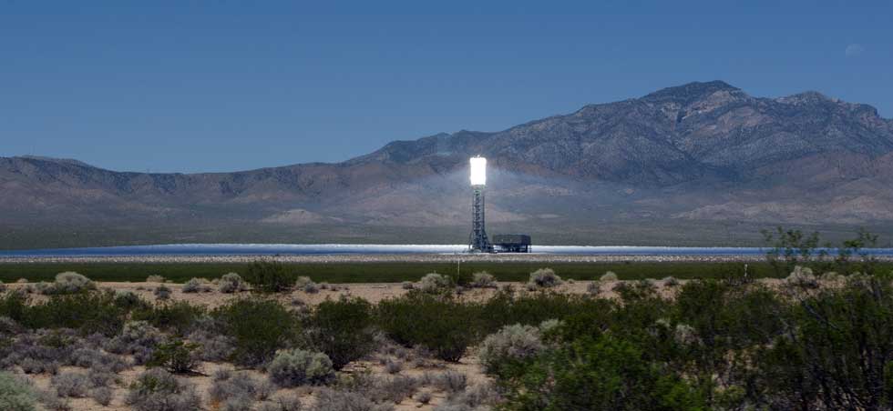
Scoot down I-15 through the desert. Just inside CA, see 3 vast solar panel arrays (I think) east of highway. They turn out to be the
Ivanpah Solar Electric Generating system.
94 degrees in Barstow where we stop for lunch.
Another odd sight: large covered fields NW of CA 58 and US 395; is Kramer Junction Solar (electric generating) Farm.
Pause at turnout for "Visitor's Center" turns out to be Rio Tinto's borax works and open-pit mine; kind of interesting, and handy location for restrooms, a feature appreciated by the experienced traveler.
Reach Bakersfield ~4:30 and check in to Padre Hotel, a fave since our Death Valley trip. Dinner at hotel's Belvedere Room, another B-field favorite. Pork osso buco, mmm..
Friday, July 18
Leave Bakersfield ~10 AM; pause on Chester Ave. to photograph
shoe store shaped like a shoe
(I'm a sucker for these things).
Reach I-5 around 11, head north; mostly very boring stretch of highway.
Pass a Zodiac boat (on trailer) with two 200 HP outboard engines mounted. Wow.
At Harris Ranch (inn, restaurant, tourist trap) 12:30.
Find secluded alcove outdoors to have picnic we brought. Quite pleasant in the shade, with trumpetvines and hummingbirds; maybe the best spot on the property.
Literally hundreds of cars, trucks, SUVs in the enormous series of parking lots, on a weekday; incomprehensible. More cars than people.
Finish picnic, visit gift shop, buy nothing, head north.
For several miles north of Harris Ranch are numerous cranky billboards blaming Congress for not giving area landowners as much water as they want. Similar to last year's array except that they no longer single out Senator Feinstein. They all look the same - there are two styles, each with the same message - and I suspect they are all on one owner's land.
Pass sign for "Pleasant Valley State Prison". It pays to advertise...
Over Altamont Pass, see first view of fog, much relieved, turn off car's A/C for first time in days.
And return to Oakland. There's no place like home.