| PFP Home > The Incompleat P.F. > Collections and Obsessions > Maps |
|
(scroll down)
|
|
|
|
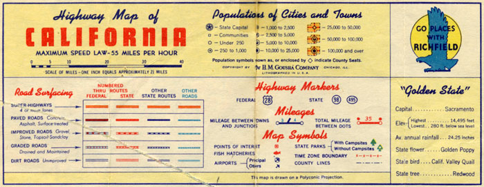
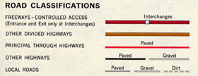
Road map legends were crammed with details that fascinated me. The most important, from my point of view, were the road classifications and the cities and town symbols. The ultimate in roads was the "super-highway," here in 1946, the year of my birth, indicated by that impressive-looking double red line with yellow fill. If you had one of them babies in your neighborhood, you knew you were in an Important Place. An even higher ranking for your stomping grounds was for it to have a good city or town symbol. The elevation from a mere circle to having the actual city limits defined and shaded yellow was a highly desirable goal, I felt.
|
|
|
 |
|
|
|
 |
|
|
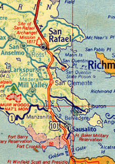
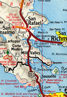
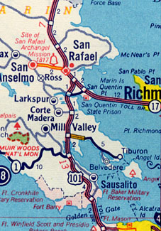
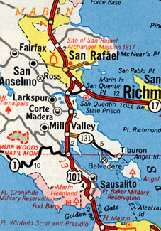
| Here in 1946 you can see that Larkspur, though represented by a lowly crosshatched circle, is at least ahead of its neighboring "Twin City" Corte Madera, and it's also favored by bold type. In actuality, Corte Madera had been unfairly stigmatized by having some of its population siphoned off for the non-existent town of "San Clemente," a holdover from the days when railroad stops were regarded as community divisions. Another one of those is "Manzanita," between Mill Valley and Sausalito.
You'll also note that the "super-highway" portion of Highway 101 peters out into two lanes north of San Rafael.
|
|
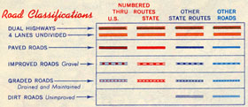 |
The end for the "super-highway" came in 1958, when its designation was downgraded to "4 lanes undivided." There was a new king, the "dual highway," with a green fill between the two red stripes. |
|
 |
|
|
|
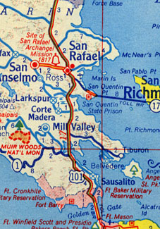
| 1958 also saw Larkspur and Corte Madera on equal footing population-wise, and my home town has also fallen even further behind San Anselmo. The fictitious communities of "San Clemente" and "Manzanita" have been consigned to cartographic never-neverland, and Highway 101 is now el primo all the way.
The "Miracle Mile" between San Rafael and San Anselmo is designated as "undivided," even though it really was divided. A city street in boulevard format did not fit into the arbitrary pigeonholes which the H.M. Goushá Company, in its wisdom, had devised.
|
|
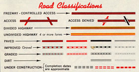 |
Well, as all good things must, the dual highway's reign too came to an end in 1961. The freeway had come into its own and, as if to symbolize a complete break with the past, an entirely new style of line was created: three narrow black lines filled with red. |
|
 |
|
|
| 1961 still saw the competing Twin Cities neck-and-neck in the town symbol derby, but two, count 'em two, freeways snaking through Marin looked mighty impressive. It was also good to see the high degree of precision in acknowledging that Highway 101 north of Lucas Valley was not yet in full freeway status. |
|
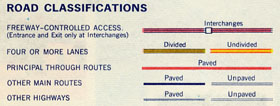 |
Then, in 1965, the double red with green fill was retired in favor of a greenish-brown variant of the freeway line called "four or more lanes divided." Still, this provided me with all-important ranking information. |
|
 |
|
|
|
| 1965 also saw Larkspur finally emerging from the ignomy of the cross-hatched circle, though this new-found glory was mitigated to some extent by still being shown as even with Corte Madera.
Highway 101 is now all-freeway all the way, and Marin even gets a bit of the new "four or more lanes divided" on the road to Tiburon, though in truth that thoroughfare was no different in kind than the Miracle Mile, still indicated as "undivided."
|
|
 |
The end finally came in 1966, when the once-proud designator of the ultimate in highway modernity, the double red with yellow fill, was banished without fanfare. The world truly was a new place. |
|
 |
|
|
|
| 1972: a banner year. Larkspur is even with San Anselmo and ahead of Corte Madera. As you can see, San Rafael becomes the first Marin community to make it into the Big Time.
The road to Tiburon has been widened a bit further, and H.M. Goushá has apparently thrown up its hands over the Miracle Mile situation.
The map collection stops in 1972, so my long-held hope to see my home town displayed in all its city-limited glory was not to be. This town symbol business was probably responsible for the population projections I formulated when I was around 10 or so. I was anxious to know when Larkspur would reach the next level of symbol hierarchy so, using yearly World Almanac population listings, I devised some kind of formula to extrapolate future population growth. Unfortunately, that formula and its results are lost in the mists of time.
|
|
|
|
|
next > |
|
|
|
|
|
|
|
|
|
|
|
|
|
|
|