| Meetings | Groundwater | Government | Traffic | Urban Sprawl | Land Use | Quality of Life | Links |
|
|
||||||||
|
|
posted December 7, 2003 Politicians have never seriously debated whether groundwater resources are sufficient in the south Santa Rosa plain. In fact, they seem to ignore the issue. But our underground water source appears to be seriously depleted. Steve Carle Ph.D., a local geohydrologist demonstrates this severity with readily availble sources of information and provides us with ample lines of substantiation. Steve Carle is the O.W.L. Foundation's chief science advisor.
Groundwater Overdraft in the South Santa Rosa Plain
Most landowners in the unincorporated community of Penngrove rely on groundwater for water supply. Rohnert Park and northern Penngrove both share the same groundwater resource, the aquifers located in the southern portion of the Santa Rosa Plain subbasin (DWR 1982; DWR 2003). Petaluma and southern Penngrove share the aquifers of the Petaluma Valley basin. http://www.dpla2.water.ca.gov/publications/groundwater/bulletin118/basins/2-1V3.1.pdf However, there are no impervious geological barriers dividing the Santa Rosa Plain and Petaluma Valley aquifer systems. Most of the basins and subbasins in Sonoma County are hydraulically connected below the ground surface, as indicated by U.S. Geological Survey and DWR maps (USGS, 2003; DWR, 1975). http://ca.water.usgs.gov/groundwater/gwatlas/coastal/aquifers2.html Contemporaneously with the Rohnert Park’s urban expansion, water levels have declined by as much as 150 feet in Penngrove since the 1960s (RP, 2000). http://www.penngrove.info/web-pix/pdf-files/rp_eir_groundwater.pdf Many Penngrove landowners have replaced wells or lowered pumps more than once. http://www.penngrove.info/GroundWaterOverdraftLetter.htm As a result of excessive pumping by the City of Rohnert Park and other factors discussed below, more groundwater is being pumped out than what is naturally put back or “recharged” into the aquifers. In hydrologic terms, this is called “overdraft.” According to the California Department of Water Resources (DWR,2003):
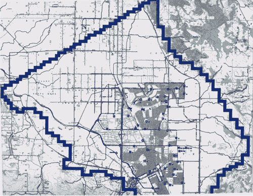
http://www.dpla2.water.ca.gov/publications/groundwater/bulletin118/Bulletin118-Chapter6.pdf (See PDF page 20) For over 25 years, excessive groundwater pumping within the City of Rohnert Park has induced critical conditions of overdraft, causing outrageous water level declines and dry wells in Penngrove. Rohnert Park EIR Groundwater Modeling Study In the process of expanding its “Sphere of Influence” into Penngrove and other unincorporated areas, the City of Rohnert Park had to evaluate cumulative long-term impacts of its groundwater pumping from over 40 municipal wells since the late 1950s. A groundwater modeling study was included in the “Hydrology, Flooding, and Water Quality” section of the “Revised Draft Environmental Impact Report” (EIR) for the City of Rohnert Park’s General Plan 2020 (RP, 2000). The groundwater study focused on the southern portion of the Santa Rosa Plain subbasin (the Subbasin) outlined in blue in Figure 4.10-3 of the EIR and shown below. http://www.penngrove.info/web-pix/pdf-files/rp_eir_groundwater.pdf (See PDF page 13)
The Subbasin encompasses the City of Rohnert Park, the City of Cotati, Sonoma State University, and outlying unincorporated areas including the northern portion of Penngrove (est. 1882). Rohnert Park (est. 1957), with a population of 42,500 in January 2003, is by far the largest water user within the Subbasin. Rohnert Park currently relies primarily on groundwater and secondarily on contracts from the Sonoma County Water Agency (SCWA) for water supplies. http://www.rpcity.org/services/pwater.cfm
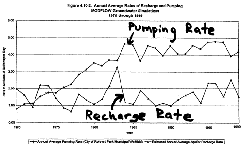
In Figure 4.10-2 of the EIR (see above), average annual recharge rates are compared with annual average pumping rates for the City of Rohnert Park’s municipal wellfield. Since 1975, the pumping rate has exceeded the recharge rate, increasing from 1.7 mgd to an average of about 4.3 mgd since 1984. By its own admission, Rohnert Park extracts groundwater in gross excess of the estimated average recharge rate of 1.60 mgd (RP, 2000, p. 4-146).
Why “Safe Yield” is not Sustainable Most policymakers assume that “safe yield” is a “sustainable” pumping rate equivalent to natural recharge. However, this assumption is flawed because it does not take into account discharges of groundwater into streams, springs, or marshes. An editorial by Marious Sophocleous in the prestigious hydrogeology journal, Ground Water, explains (Sophocleous, 1997):
A better definition of safe yield would address the sustainability of the system – not just the trees, but the whole forest; not just the fish, but the marine food chain; not just the ground water, but the running streams, wetlands, and all the plants and animals that depend on it.
Water Level Declines In the 1950s, groundwater levels ranged from 5 to 20 feet below ground surface in the vicinity of Rohnert Park (Cardwell 1958). DWR (1987) mapped a “cone of depression” in the vicinity of Rohnert Park, including the largest water level declines between 1977 and 1983 shown below:
Parsons Engineering Science, Inc. (1995) noted drops in water levels as much as 130 feet between the 1960s and 1983. Between 1975 and 1999, water levels declined by 100-150 feet along the eastern boundary of the proposed Urban Growth Boundary, most of which presently consists of rural lands within the Penngrove community (RP, 2000, p. 4-146). http://www.penngrove.info/web-pix/pdf-files/rp_eir_groundwater.pdf
Adverse impacts to landowners are extensively documented by well surveys conducted by Penngrove resident John King in 1999 and 2003. In recent years, some Penngrove residents have resorted to trucking in water. Groundwater Management
http://www.dpla2.water.ca.gov/publications/groundwater/bulletin118/Bulletin118-Chapter2.pdf According to State law, groundwater management in California is the responsibility of cities, water districts or agencies, and the County (DWR, 1999). http://www.groundwater.water.ca.gov/technical_assistance/gw_management/index.cfm Penngrove straddles the watershed divide between the Santa Rosa Plain subbasin and the Petaluma Valley basin. Penngrove is also vulnerably sandwiched between two large pro-growth oriented municipalities, Rohnert Park and Petaluma. DWR (2003) identifies the Sonoma County Water Agency and the cities of Rohnert Park and Petaluma as the local agencies responsible for groundwater management in the regions near Penngrove. http://www.dpla2.water.ca.gov/publications/groundwater/bulletin118/basins/1-55.01_Santa_Rosa_Plain.pdf http://www.dpla2.water.ca.gov/publications/groundwater/bulletin118/basins/2-1V3.1.pdf No groundwater management plans have been initiated by any of the responsible local agencies in Sonoma County (DWR (2003). In fact, SCWA and the North Marin Water District (which consumes 23% of SCWA’s water allocation) are two of the few water agencies in California on record as having “no interest” in groundwater management (DWR, 1999). http://www.dpla2.water.ca.gov/publications/gwm_report.pdf Groundwater management is not even mentioned in the “Revised Draft Sonoma County Water Agency Water Policy Statement 2002.” http://www.penngrove.info/download_SCWA_Water_Policy_Draft.htm Yet SCWA currently pumps over 5 million gallons per day, enough to supply about 30,000 residents, from its three “emergency wells” in the Santa Rosa Plain. And why are these emergency water supplies being pumped out (and exported to Marin) without a drought and without a plan for groundwater resource sustainability? Sonoma County’s local governmental power structure facilitates an opportunity for cities to overdraft the groundwater resource to the detriment of the rural areas because the Supervisors, who have the ultimate power in land use decisions, also serve as the Board of Directors for the SCWA:
It remains to be seen whether new state laws requiring proof of sufficient water supplies for new developments will have any impact on the power alliance between the Cities and the SCWA. http://www.penngrove.info/sb610sb221explained.htm The State has provided the County, cities, and SCWA with a step-by-step guidebook to integrating water and land use planning and groundwater management. http://www.owue.water.ca.gov/Guidebook_101003.pdf The State also offers generous funding opportunities to local governmental agencies. http://www.groundwater.water.ca.gov/financial_assistance_programs/index.cfm Alternatives to local management of groundwater resources are lawsuits and adjudication. Adjudication is a court decision to strip local agencies of control and govern the basin through a court-appointed watermaster. Seventeen basins in California are adjudicated. http://www.groundwater.water.ca.gov/technical_assistance/gw_management/index.cfm
Penngrove Lawsuit The only effective groundwater management action to date has been a lawsuit filed in August 2000 by John King and the South County Resources Preservation Committee of Penngrove over the Rohnert Park EIR. http://www.penngrove.info/johnking-profile.htm As a condition of a settlement agreement, the City of Rohnert Park was required to cut pumping in half before developing outside 1999 city limits and to request that SCWA develop a groundwater management plan for Rohnert Park. SCWA rejected this request, confirming that neither Rohnert Park nor the SCWA are willing to take on their responsibility to manage groundwater resources in a sustainable manner. http://www.penngrove.info/RP-demands-groundwater-Mgt-Plan.htm
The Sonoma County Local Agency Formation Commission (LAFCO) is charged with a state-mandated oversight role to stop misuse of land resources by discouraging urban sprawl and preserving agricultural land resources. http://www.calafco.org/about.htm LAFCO approved a gross misrepresentation available water resources with complete ignorance of the location of State-identified natural recharge areas. The Rohnert Park EIR erroneously stated a “planned” average annual allocation of 15 mgd from future SCWA contracts. http://www.penngrove.info/web-pix/pdf-files/rp_eir_groundwater.pdf According to SCWA (2000), Rohnert Park is allotted a “maximum monthly delivery rate” of 15 mgd with an annual limit of 6.7 mgd (not 15 mgd), which is less than 1999 demand of 6.9 mgd (RP, 2000). http://www.penngrove.info/web-pix/pdf-files/UrbanWaterManagementPlan2000.PDF Rohnert Park trumped up so-called “planned” future annual SCWA allocations by a factor of 2.5. However, both the 15 mgd and 6.7 mgd “planned” future SCWA allocation figures have proven to be “paper water” since the Friends of the Eel River Appellate Court decision of May 16, 2003. http://www.penngrove.info/Eel-River-suit-impact.htm Rohnert Park’s 2003 SCWA allocation remains only 5.2 mgd due to “temporary impairment” (SCWA, 2001). http://www.scwa.ca.gov/newagreementhome.html SCWA General Manager Randy Poole admits that the cause of “temporary impairment” is no longer only a matter of transmission capabilities, but of water rights. “Contemplated” SCWA water supply increases of 35% are not legally secure (they never were), and current SCWA water rights may only suffice for a few more years of urban growth in Sonoma and Marin counties. http://www.penngrove.info/SCWA-sets-limits.htm Cities like Rohnert Park, Petaluma, and Santa Rosa based their urban growth plans through 2020 on the paper water of “contemplated” Eel River diversions - water supply projections that were not legally secure.
Next Development Target: Natural Recharge Areas Much of the past, current, and future environmental impacts related to groundwater overdraft hinges on the fate of future land use decisions in State-identified natural recharge areas. Rohnert Park hopes to bail itself out of a multi-million dollar budget crisis, in large part, by developing lands identified by DWR (1975) as natural recharge areas. http://www.sonoma.edu/users/n/norwick/Document/Ford/FIGURE15B.JPG The impact of covering over prime natural recharge areas with urban sprawl was not evaluated by Rohnert Park’s EIR, either. Large tracts of State-identified recharge areas are now engulfed by Rohnert Park’s “Sphere of Influence.” The City of Rohnert Park has specific plans to pave over these recharge areas with urban sprawl. http://www.rpcity.org/cityhall/specificplans.cfm As shown below, the recharge areas striped in red are targeted for future development within the “annexation areas” shaded in light blue with dashed borders:
If the current groundwater management policy of “no action” by local agencies continues, the recharge areas necessary for sustainability of the groundwater resource will be covered over by urban sprawl. An unknown portion of Penngrove’s groundwater resources will be permanently choked off, and future groundwater quality will be threatened. http://www.dpla2.water.ca.gov/publications/groundwater/bulletin118/Bulletin118-Chapter2.pdf (see PDF pages 20-21) As explained by the State (DWR, 2003), safe yield is the amount of groundwater that can be withdrawn from a basin without adverse impact. Safe yield is reduced by urban development: “One of the common misconceptions is that safe yield is a static number. That is, once it has been calculated, safe yield is the amount of water that can be extracted annually from the basin without any adverse impacts. An example of a situation in which this assumption could be problematic is when land use changes. In some areas, where urban development has replaced agriculture, surface pavement, storm drains, and sewers have increased runoff and dramatically reduced recharge into the basin. If extraction continues at the predetermined safe yield of the basin, water level decline and other negative impacts could occur.” http://www.dpla2.water.ca.gov/publications/groundwater/bulletin118/Bulletin118-Chapter6.pdf Rohnert Park’s plans to urbanize recharge areas will drastically reduce safe yield.
Adverse Impacts Groundwater levels beneath the Subbasin have steadily declined since the 1970s despite many years of average or above-average rainfall. Overdraft and lack of management have imparted and will impart substantial water quantity-related adverse impacts:
Water quality issues cannot be ignored:
Ignoring Past State Recommendations The threat of critical conditions of overdraft is not new. According to DWR (1979):
Currently, the cities, county, and water suppliers lack technical expertise and genuine interest for groundwater sustainability. The City of Rohnert Park is now experiencing a multi-million dollar fiscal crisis, in large part because of unrealistic growth projections based on “paper water.” http://www.imakenews.com/calrac/e_article000131611.cfm Rohnert Park is finally installing water meters after being forced to do so (SCWA, 2001), at a cost of $2.55 million. http://www.owue.water.ca.gov/finance/docs/PSP_114.PDF Much of Rohnert Park’s financial predicament originates from its unmanaged exploitation of groundwater resources. New State laws now reduce opportunity for receiving State funding for water projects and drought assistance if groundwater management plans are deficient or lacking. http://www.leginfo.ca.gov/pub/01-02/bill/asm/ab_0901-0950/ab_901_bill_20011009_chaptered.pdf Are Sonoma County’s local governmental agencies responsibly preparing for the next drought? What Next? The SCWA, the cities, and the County must realize their responsibility to maintain sufficient and sustainable water supplies of potable quality for all citizens in Sonoma County. At present, private citizens are expending large amounts of time, effort, and money to convince local governmental agencies to assume their duty and responsibility for protecting water supplies, despite great resistance from those agencies. Eventually, a groundwater management plan and program must be developed by the SCWA, cities, and the County to ensure sustainability of the groundwater resources.You can help! Please contribute generously to the O.W.L. Foundation to ensure substantive action and wise decision-making for open space, water resources protection, and land use changes affecting Penngrove and other rural communities in Sonoma County.
References DWR (1975) “Evaluation of Groundwater Resources: Sonoma County (Volume 1: Geologic and Hydrologic Data) http://www.sonoma.edu/users/n/norwick/Document/Ford/gwsforeword.html DWR (1979) “Meeting Water Demands in the City of Rohnert Park.” DWR (1982), “Evaluation of Groundwater Resources, Sonoma County, Volume 2: Santa Rosa Plain” DWR Bulletin 118-4 DWR (1987), “Santa Rosa Plain Ground Water Model” DWR (1999), “Groundwater Management in California” http://www.dpla2.water.ca.gov/publications/gwm_report.pdf DWR (2003), “California’s Groundwater” Update
2003 Bulletin 118 Parsons Engineering Science, Inc (1995), “Evaluation of Groundwater Supply Alternatives Water Supply and Transmission System Project” prepared for Sonoma County Water Agency RP (2000), Hydrology, Flooding, and
Water Quality” section of the “Revised
Draft Environmental Impact Report” City of Rohnert Park’s
General Plan 2020 SCWA (2000), “Sonoma County
Urban Water Management Plan 2000” SCWA (2001), “Memorandum of Understanding Regarding Water System Transmission System Capacity Allocation During Temporary Impairment” Sophocleous, M., (1997), Managing Water Resource Systems: Why “Safe Yield” is not Sustainable, Ground Water, v. 35, n. 4, p. 561. USGS (1958), “Geology and Ground Water in the Santa Rosa and Petaluma Valley Areas”, U.S. Geological Survey Water-Supply Paper 1427 USGS(2003), “Groundwater Atlas
of the United States, California and Nevada” |
|
| ©2003 Penngrove.info :: Request Email Bulletins :: Contact Us :: | :: Who We Are :: Supporters :: |