There has been a huge amount of speculation concerning the location of Atlantis. To a certain extent, many of the conclusions are partially true, as the Atlantean civilization was not located in just one part of the planet, but was global, and more globally oriented after the arrival of the alien visitors/colonists.
However, I have been given a vision (and I truly mean that) of where the heart of Atlantis lay. In the vision, I saw a three-dimensional model of the world in full color rotating before my eyes. Although all else was the same, with contours represented and so on, the seas were shown as empty basins. The globe was rotating from left to right before to my eyes, as though I were looking on it from space, with first Eastern Europe, then Europe, then the Atlantic Ocean before me.
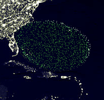
When the Atlantic was fully centered in my vision, the image slowed to a stop. Then a wireframe structure was formed off the eastern coast of America, filling out a huge area, somewhat like a flattened egg, with the larger section to the west. The span of the wireframe from north to south was perhaps from North Carolina to the tip of Florida. The wireframe model went far out into the Atlantic; perhaps a third of the way across toward the African coast, or perhaps a bit further, as shown in the following image.

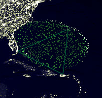
Long after being given that vision, I Googled the Bermuda Triangle. Much to my interest, I discovered that the bulk of where I saw Atlantis falls within the area called Bermuda Triangle. I had heard of the Bermuda Triangle, but my geography was kind of weak and I always thought that Bermuda was in the Caribbean. Instead, it is out in the Atlantic, and the Bermuda Triangle is the area roughly enclosed by lines drawn from Bermuda to Miami, Flroida, to San Juan, Puerto Rico, though according to this site that focuses on the Bermuda Triangle, it actually covers almost exactly what I saw as the former location of Atlantis. Intrigued, I have superimposed the "triangle" on the image of the former location of Atlantis.
