LAND SURVEYING
Click thumbnail to enlarge
   |
Project:
Richmond San Rafael Bridge Seismic Retrofit
Client:
Caltrans District 4
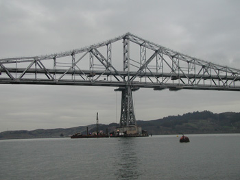
Caltrans is in the midst of implementing a seismic retrofit
of the Richmond-San Rafael Bridge as part of the legislatively
mandated Toll Bridge Seismic Retrofit Program. The main
objective of the project is to increase the bridge’s strength
and flexibility.
The Richmond-San Rafael Bridge was first opened to public
traffic in 1956. The bridge is approximately four and a half
miles of stacked traffic lane construction, with the upper deck
of traffic flowing westerly and the lower deck flowing in the
opposite direction. The bridge spans across the waters of San
Pablo Bay and connects Marin and Contra Costa counties.
The entire portion of the bridge that spans the bay waters is
supported by more than fifty pairs of concrete piers that extend
well into the bay floor. The height of the bridge is also
constructed to accommodate the passage of large cargo ships that
provide world trade imports and exports. Each pair of existing
bridge support piers were strengthened with massive concrete
retrofit jackets that were fitted together by installing long
bolts that extend through both jackets. This work took place
both above and below the water’s surface.
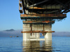
Brelje & Race provided surveying services associated with the
seismic retrofit of the Bridge, including construction layout
for bolt patterns on every retrofit jacket (as many as 30 holes
each on more than 50 jackets), which was essential to strengthen
the bridge support system; as well as performing a control
survey that allows Caltrans to monitor any future bridge
movement that could result from an earthquake, greatly enhancing
bridge safety in the long run.
|


;)
;)
;)