 |
1. Cover Page 2. Table of Contents 3. Objectives 4. Property 5. Resources 5.1 Forest Health 5.2 Soils 5.3 Water Resource 5.4 Timber 5.5 Wildlife 5.6 Forest Grazing 5.7 Aesthetics and Recreation 5.8 Forest Products 6. 10-Year Plan |
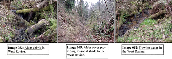
Forest Stewardship Plan 5.3 Water Resources, Riparian Areas and Fisheries Habitat (Streams & Waterways Map) Resource Description The Wild Thyme Farm forest is in the Chehalis River watershed. There are two intermittent streams in the forested region of the property named East and West ravine in accordance with their geographical location. Each ravine has two tributaries named East and West tributary, also in accordance with their geographical location. The Department of Natural Resources rates the West ravine Type 5 and the East ravine is not recognized on the basemap but according to established criteria should be considered Type 5. There are no true wetlands in the forested region. There have been multiple culverts installed along the streams where they intersect with roads for drainage purposes. Because the streams on the property do not bear fish, applicable water laws do not significantly inhibit management activities. The riparian influence in this forest is minimal, primarily providing topographical complexity and drainage. The stream bank stability is good overall although there is a minor amount of instability where road-cuts have eroded. There is evidence of amphibian presence in downed woody debris surrounding the streams. There are adequate trees for future stream debris, particularly in the West ravine where alder is prolific (Images 53, 52). There is adequate stream shade in the East ravine where mixed conifer and hardwood dominate. The West ravine has a minimal overstory, however various berry species border each side of the stream providing some cover when leafed out (Image 49).
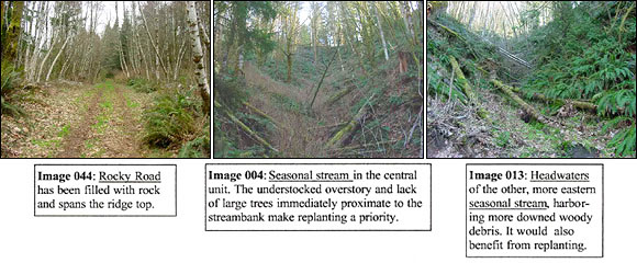
Enhancement and Protection Roads have been cleared with consciousness of erosion and care has been taken to minimize that possibility. Most roads are closed to vehicles during the wet season. Rocky Road, spanning the ridge on the south end of the property, has been filled with rock (Image 44). There is significant natural regeneration in roadcuts. Gates have been installed to keep cattle from entering the majority of the forested area. Western red cedar has been replanted in some areas. Septic systems do not effect the forested area. Woody debris in streams is most comprised of hardwoods, which will decay fairly rapidly. Management Recommendations I recommend that underplanting of Western red cedar be initiated in riparian zones if funding can be acquired through the SIP program. In areas where erosion is likely I recommend that roads remain closed. Culverts should be maintained and kept clear. The headwaters of the streams provide ample opportunities for restoration (Images 4, 13). Between habitat creation for small mammals and amphibians, soil stabilization through replanting, and regeneration of a native and diverse plant cover, the streams on the property could move from protected and mildly enhanced to central features of the forest. I recommend that restoration buffers be established formally or informally, and restoration efforts begin within these zones provided funding is obtained through the SIP program. |
|
|
|
|
|
www.wildthymefarm.com © 1998-2009 • 72 Mattson Road, Oakville WA 98568 USA. Tel: (360) 273-8892 |

